 |
|
|
|
| Weather Textual Reports | ||||
 |
 |
|||
| Pocket PC | Smartphone | |||
|
METARs WingX interprets and color-codes the individual METARs. By looking at these colors, a pilot can quickly get an idea of the weather in an area or along a route. If a route is entered, WingX will display METAR-reporting airports along the route. |
|
TAFs
WingX displays the TAFs of nearby TAF-reporting airports. If a route is entered, WingX will display TAF-reporting airports along the route. |
|
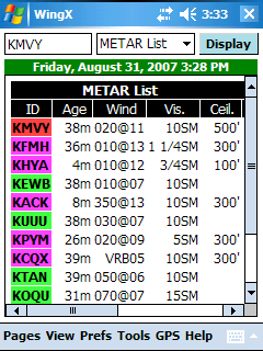
METAR List WingX extracts important pieces of METAR information and displays them in an easy-to-read color-coded table with each METAR-reporting airport being displayed on a single line. The METAR List consists of 10 columns:
|
|
Winds Aloft WingX displays winds aloft information of nearby winds aloft-reporting stations. The format is very similar to the familiar DUATS columnar format except that the display is a lot cleaner and easier to read. Wind components with wind speeds greater than 99 knots are reported as 230@150 instead of the DUATS-encoded 730@50 (for example). If a route is entered, WingX will display winds aloft-reporting airports along the route. |
|
Temperatures Aloft WingX displays temperatures aloft information of nearby temperatures aloft-reporting stations. The format is very similar to the familiar DUATS columnar format except that the display is a lot cleaner and easier to read. Negative temperatures are shown as negative numbers. WingX will even automatically calculate the freezing level. If a route is entered, WingX will display temperatures aloft-reporting airports along the route. |
|
6-Hour Trends WingX displays six pieces of weather trending information. This information is extremely critical to accurately analyze an airports weather condition and to predict future weather conditions. For example, an airport may be VFR with unlimited visibility, but if the temperature and dewpoint are trending closer together, there is the real possibility that low-level fog will form. This level of information is difficult to obtain from DUATs or a FSS weather briefer as it would require obtaining and interpreting both past and present METARs and then building a picture of the trend - an almost impossible task. The six pieces of information displayed are:
|
Note: Images on this website may be slightly different to what you see on your Microsoft Pocket PC 2002, Microsoft Mobile 2003, Mobile 5.0, or Mobile 6.0 device. Disclaimer: 14 CFR 91.3 says that you, the PIC, are responsible for the safety of the flight. WingX products are intended to assist you in your preflight and inflight activities. While Hilton Software makes every effort to ensure the accuracy of its calculations and data, Hilton Software cannot absolutely guarantee the accuracy. By using WingX products, you agree to hold harmless Hilton Software and those persons acting on its behalf for any and all, but not limited to, liability, bodily injury, and/or property damage arising from the use of WingX products.
Copyright © 2003-2007 Hilton Software LLC All rights reserved. |


